The sun is lazy this time of year in south-eastern Arizona… It is still dark at 7am. This ain’t Colorado, where we could see Kansas at VERY FIRST LIGHT – from our bed! By the time El Sol illumines our Rosalita, it is nearing 7:30am, late for an early riser like me. That’s OK, it just means we get out of the RV later… when the perfect light is disappearing. I might add here, that it is really cold in the mornings, unfit for bare hands or photographic lens, they tend to fog-up. So, loooong story short, we are taking a few short jaunts in and around Safford, which, amazingly has quite a lot to offer.
Today, we went east and north of Safford to the West Gila Box Conservation and Riparian Area. The road is mostly paved, but a couple of small areas escaped the paving, must have been some feud… over right-of-way. It is about 10 miles back into a box canyon, but we didn’t see the ‘box’. We wondered if this was the same Gila Box Conservation (which would have been the east entrance) that we traveled through back from Morenci Copper Mine last month? This road might connect up at some intersection along that road also. The road, once we traveled inward to the canyon, was narrow, very windy, and with hair-pin curves where we couldn’t see whether the road went on or if it dropped off. At one point in the adventure, there was a 19% grade down into the canyon… We chose NOT to travel down that road!!!


Steep gravel/dirt road
At the bottom of the canyon, the Gila River meanders on to San Carlos Lake, past Yuma, and on into California. The River may well travel underground at different parts of its journey.

Mt Graham in the background


Rock surface being carved out by the wind and rain (affectionately, ‘eat-outs’)


Exploring along a path to get a closer look at the river, I saw a corridor of fallen leaves just begging to have the movement of bare feet shuffling through their leaves and picture taken.

Nature is so amazing… here is nature wearing down this rock with pebbles swirling inside a pocket hole.

Traveling back into the canyon about 5 miles further, is Bonita Creek, not sure where this creek originates – it is a lazy creek that is refuge to birds, deer, javelina and many other species of animals. They do stock some fish in the stream, surviving is another matter – I did spook some ducks out of the cat tails at the stone wall by the river, however… Walking along the marshy creek, I got my shoes very muddy as I sank ankle deep in dark brown muck. We saw no other signs of life other than an occasional bird and the ‘dashing ducks’.

Along the campground these pillars are being carved-out by Nature at her finest…


Patti sat by the lazy river meditating and found a huge leaf (not sure what kind of leaf).

This creek was once settled by a few pioneers that had some kind of livestock. The dilapidated remnants of the buildings were covered with vines and tree suckers growing up through the ancient support beams and barely existing ‘roof’, one had to look very closely to even see there was a structure once there. It would have been a very secluded, peaceful hiding place in times gone by, AND a heck of a ride or walk to get supplies.
We turned Gypsy south-west and headed back to Safford, vowing our next day-trip would be a picnic trip, ’cause there was no place to eat, get gas or water, once we left Safford.
East Entrance to Gila Box Conservation and Riparian
The next day, with picnic in hand, we decided to revisit the East Entrance of Gila Box and see if they connected, through the mountain range. We had come through this East Entrance when we came back home from Morenci and Clifton.
The road is 21 miles long from beginning to end. There is a sign indicating a ‘primitive road’ at both entrances. Luckily for us the road had been recently graded and it had not rained in a while. Just like the road on the west entrance there are hair-pin curves, and unmarked drop-offs on both sides of the road. The only difference is this road is gravel and the West entrance is paved.

About 17 miles north of the Hwy 191 turnoff, is a picnic area where we enjoyed our exquisite lunch at the glorious Gila River Roadside Cafe. Peace and tranquility were served as appetizers, the main course was Love rolled in a tortilla, and the Sun offered us vitamin D for dessert.

On our way in this time, we started at the south end of the road to retrace our tire tracks. We found a map of the history along this road and mile markers to aid in our search for the ‘story inside the story’.
This road (Old Safford Highway) was built by prisoners from 1914 – 1920. What a back breaking job!!! Don’t know if they had any kind of equipment to help build this road, we surely HOPE SO. Prisoners or no.
At mm (mile marker) .3 there are two grave sites where prisoners were laid to rest. The first internment was for a prisoner who died of apparent natural causes (?). The graves are mostly above ground as I would imagine this terrain would be very difficult for digging graves. There are rocks covering the grave to keep the wild things from carrying the body off. Different wild life have been living in and around the rocks as evidenced by the tunnels through the cactus… great protection. His headstone reads “Convict, Sick, Died 1916”; no name, no nothing, only that he was a prisoner.


Sick Died 1916″
The second grave was about 50 feet away and had the same appearance of large rocks and cactus adorning the ‘roof’. This prisoner was shot while trying to escape – his grave is larger, was he a bigger man? His headstone reads, “Convict, Shot 1916” – again no name, no nothing…


Shot 1916″
At mm 3.5, is what we suspect is the road that connects the East and West Gila Box Conservation Area. Deadman Canyon Road (only six miles long) is the connection road to the West entrance, so we venture down this much worse ‘primitive road’. This road was far worse than the entrance ‘primitive’ dirt/gravel road. As I maneuver around but mostly over, the horribly un-uniform rocks, Patti is being bounced around like a ping-pong ball. At about 1/2 mile in, we call it quits. We decide to have lunch there, even though there is no picnic table or river, even the sun was playing peek-a-boo, being stingy with it’s vitamin D. After our Gila ‘Box’ lunch, we traversed back the 1/2 mile to the main road. We left this journey for another day, if ever… Up the main road another 2 tenths of a mile, there was an old, caved in cinder (ash) mine. There was not much to photograph of this history as the mine was in shambles.

This entire area, as holds true for most of our jaunts, seems to have been created by volcanos, accounting for the large, strange shaped, weather beaten rocks that have given them such volcanic character.
MM 3.6 displayed in all Natures’ wonder, the striations of the spewing liquid molten rock, making it hard to doubt the geology…


Deciding this side of the Gila Box was much less interesting with no water or changing leaves, we head back out. The sweeping vistas we see are all the same; dirt, cactus, no trees and no water, “we’re outa here!”
Ah, but one last rock formation catches my attention…

Dos Cabazes Peak

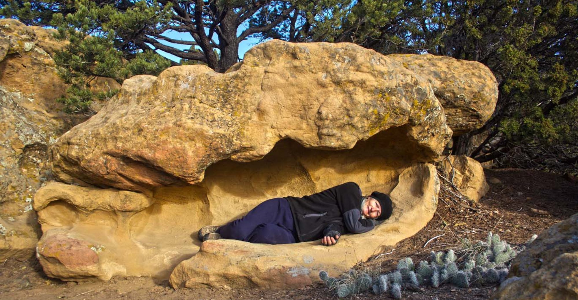
One Last Rock…

I’ve been surfing online greater than three hours as of late,
yet I by no means discovered any fascinating article like
yours. It’s beautiful worth sufficient for me. Personally, if all web owners and bloggers
made good content as you probably did, the web will likely be a lot
more useful than ever before.
LikeLike